LEADTOOLS (Leadtools assembly)

Send comments on this topic. | Back to Introduction - All Topics | Help Version 17.5.11.5
| Leadtools Namespace > RasterImage Class > AddBeziersToRegion Method : AddBeziersToRegion(RasterRegionXForm,RasterCollection<LeadPoint>,LeadFillMode,RasterRegionCombineMode) Method |
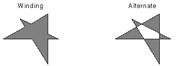
Indicates how to handle complex crossing lines.
| Value | Meaning |
|---|---|
| LeadFillMode.Winding | All pixels that are inside the resulting exterior lines are in the region. |
| LeadFillMode.Alternate | The region includes the area between odd-numbered and even-numbered polygon sides on each scan line. |

public void AddBeziersToRegion(
   RasterRegionXForm xform,
   RasterCollection<LeadPoint> points,
   LeadFillMode fillMode,
   RasterRegionCombineMode combineMode
)
'Declaration

Public Overloads Sub AddBeziersToRegion( _
   ByVal xform As RasterRegionXForm, _
   ByVal points As RasterCollection(Of LeadPoint), _
   ByVal fillMode As LeadFillMode, _
   ByVal combineMode As RasterRegionCombineMode _
)
'Usage

Dim instance As RasterImage
Dim xform As RasterRegionXForm
Dim points As RasterCollection(Of LeadPoint)
Dim fillMode As LeadFillMode
Dim combineMode As RasterRegionCombineMode

instance.AddBeziersToRegion(xform, points, fillMode, combineMode)
public void AddBeziersToRegion(
   RasterRegionXForm xform,
   RasterCollection<LeadPoint> points,
   LeadFillMode fillMode,
   RasterRegionCombineMode combineMode
)
 function Leadtools.RasterImage.AddBeziersToRegion(RasterRegionXForm,RasterCollection{LeadPoint},LeadFillMode,RasterRegionCombineMode)(
   xform ,
   points ,
   fillMode ,
   combineMode
)
public:
void AddBeziersToRegion(
   RasterRegionXForm^ xform,
   RasterCollection<LeadPoint>^ points,
   LeadFillMode fillMode,
   RasterRegionCombineMode combineMode
)
Indicates how to handle complex crossing lines.
| Value | Meaning |
|---|---|
| LeadFillMode.Winding | All pixels that are inside the resulting exterior lines are in the region. |
| LeadFillMode.Alternate | The region includes the area between odd-numbered and even-numbered polygon sides on each scan line. |
To update an existing region, you specify how the new region is to be combined with the existing one using the combineMode parameter. For more information, refer to RasterRegionCombineMode.
For more information, refer to Creating a Region.
For more information, refer to Saving A Region.
For more information, refer to Working with the Existing Region.
Target Platforms: Windows 7, Windows Vista SP1 or later, Windows XP SP3, Windows Server 2008 (Server Core not supported), Windows Server 2008 R2 (Server Core supported with SP1 or later), Windows Server 2003 SP2